|
 |
Getting Around Cape Cod
~ Route 6 (Mid-Cape Highway)
~ Route 6A
~ Route 28
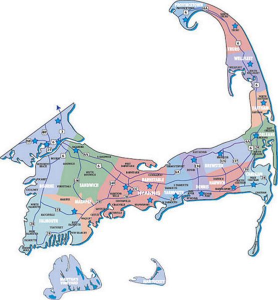
There are several major routes on the Cape that are a must to become familiar with. A few routes are strictly for convenience and speed, while meandering along others is the only way to really experience the charm and atmosphere that the Cape has to offer. HINT - pick up a detailed map of Cape Cod at one of the visitor's centers - you'll be glad you did. You can also pick up a ton of brochures and village guidebooks at the centers.
Route 6 (Mid-Cape Highway) -
First of all, the main route onto and off of the Cape is the Mid-Cape Highway - also called Route 6. This is the fastest way to get from one end of the Cape to the other, but definitely not the most scenic. It runs from the Sagamore Bridge all the way to Provincetown, the full length of the Cape. It is a 4-lane divided highway for about two-thirds of the distance, than becomes a 2-lane road. Backups during the busy summer months are notorious on this and most of the Capes major roads.
Route 6A -
Next is Route 6A, one of my personal favorites. This 2-lane road meanders along the northern side of the Cape from Sandwich to Orleans and was the main road to the lower Cape before Route 6 was built. It is the perfect drive to get a taste of quaint Cape Cod with its delightful shops, old New England churches, beautiful tree cover and traditional Cape Cod homes and buildings. History abounds on the Cape, so stop if the spirit moves you and "smell the roses".
Route 28 -
Route 28 goes south from the Bourne Bridge to Falmouth and than follows the coast along the south side of the Cape. It extends all the way to Orleans, where it meets up with 6A and 6. It's character changes as often as the villages. As you drive the length of Route 28 you will find yourself passing picturesque harbors with boats leaning into the wind, as well as shopping outlets, fast food restaurants, old Sea Captains' houses, gift shops, fishing piers, lighthouses and elegant resorts. Between the bridge and Falmouth, there is not much to see as it is more highway-like. From Falmouth you can head toward Woods Hole in the southeastern corner of Cape Cod, or proceed along Route 28 toward Hyannis. Route 28 is a mixture of city and seaside villages. As you travel through Hyannis and Yarmouth, you will experience more traffic and modern places, with smatterings of the old Cape Cod still in evidence. Once you pass into the Harwich area you begin to get away from the hustle-bustle and back into the more relaxed village setting. Chatham is one of the more upscale areas, and is the "first stop of the east wind" in the United States. In Chatham, Route 28 breaks northward along the eastern coast of the Cape, ending at Route 6. HINT - don't let the road signs that say "28 North" or "28 South" fool you. You will often times find yourself travelling in a southward direction and the sign will say "28 North", or vice versa!!
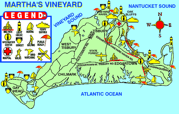
Island Transportation & Info
Getting to Martha's Vineyard
Hy-line Cruises -  - Hyannis - Hyannis
Island Queen - - Falmouth
Martha's Vineyard Chamber of Commerce
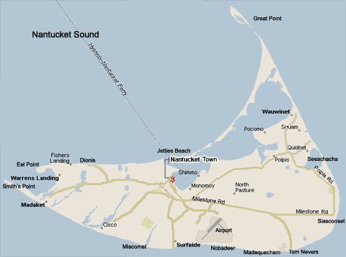
Getting To Nantucket
Nantucket Chamber of Commerce
Nantucket Island Ferry - - Harwichport, Freedom Cruise Lines
Steamship Authority - - Hyannis, Woods Hole
|